


Val d’Ajol Levayl

Danielj
User
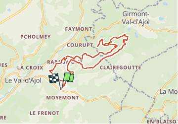

Length
18.1 km

Max alt
681 m

Uphill gradient
622 m
Km-Effort
26 km

Min alt
383 m

Downhill gradient
625 m
Boucle
Yes
Creation date :
2022-09-20 07:48:40.0
Updated on :
2022-09-20 14:27:37.664
5h55
Difficulty : Very difficult

FREE GPS app for hiking
 SityTrail
IGN / Geographical institutes
SityTrail Plus
The world is yours!
About
Trail Walking of 18.1 km to be discovered at Grand Est, Vosges, Le Val-d'Ajol. This trail is proposed by Danielj.
Positioning
Country:
France
Region :
Grand Est
Department/Province :
Vosges
Municipality :
Le Val-d'Ajol
Location:
Unknown
Start:(Dec)
Start:(UTM)
314041 ; 5310626 (32T) N.
Comments